
“The field”. “Fieldwork”. Those phrases have magic in them, of more than one kind. The modern kind is we put that phrase in email autoresponders and it seems to absolve diverse failures. Apparently, others have patience for something that is becoming increasingly rare – time for fieldwork, time to go get the data from the big “out there”. But there’s another kind, the kind that implies some nostalgia for a time when more than a few scientists did everything, including writing their papers, in “the field”. Some immersed themselves for years in the processes they were studying “out there”. Not many of us do that for any meaningful length of time anymore.
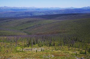
 Figure 1. White Mountains burns. 2004
fires burned hundreds of thousands of acres in this part of Alaska
This trip, on the way to “out there”, and as if to remind me of the opportunity before me, the weatherband announced a useful fact – that the “sun…..will not set”. For the five days either side of summer solstice, this part of Alaska has continual sunlight. Arctic plants and birds make use of the short season, and so can I;
when the sun doesn’t set, there is one fewer limitation on what it is possible to do in a day.
I have the good fortune to conduct science that depends on data from places with comparatively little human influence other than changing climate. Before I implied purpose by calling it “the field”, I sought solace in places that have become, at least to me, “the field.” Over the last many years, that has gradually changed, and now I come to this place and others like it to settle questions with observation, to make measurements. Maybe truer to the complexity actually unfolding here, I also come hoping to sharpen my questions to the point they can be addressed with observation at all. But that means I have traded solace for a kind of urgency because “the field” is changing fast, and the time to collect measurements is in ever shorter supply. I have replaced contemplation of wild places in wild places with the need to traverse those wild places fast enough to get sufficient data. Pursuit of that task in this place rewards simplicity and going as light and fast as possible. The equipment for this looks like an odd mix of mountain endurance sport, rural hardware store, and science fair electronics experiments.
 Figure 2. Sensor near treeline. Surface temperature sensors allow estimation of snowpack duration.
Paired with air temperature, soil temperature, and other measurements deployed in a network, variation
in watershed responses can be measured.
I’m on a bluff above the treeline ecotone, among ptarmigan leks and scattered krummholz, about 100 km northwest of Fairbanks and about the same distance south of the Arctic Circle. To the west, south, and east, the view unfolds for tens of kilometers of the rolling foothills of the White Mountains (Fig. 1), with peaks reaching 1500 m to the north behind me. These are not the White Mountains famed for high wind in New Hampshire, nor those famed for ancient bristlecone pines in Inyo County, California.
These White Mountains are short by those standards, but have a different superlative – they are part of a larger geography between the Alaska Range to the south and the Brooks Range to the north that, in some summers, rivals the entire lower 48 states for area burned by wildfire. In part that is because Fairbanks gets less annual precipitation than Tucson, AZ and is warming at twice the global average. Recently, we also have snowdrought; fire season begins during our dry, bright spring rather than in the transition between spring and our wet late summer.
Over a decade ago, these foothills were an expanse of spruce (Picea glauca in the uplands, P. mariana over permafrost, and depending on whom you believe, their hybrids where nothing limits the possibility), all of it diffusing into textbook treelines, three kinds of tundra, and snow peaks. From here, I can also glimpse the future. In this small part of an immense fire-prone geography, wave upon wave upon wave of silver and charred stems stand anchored in a sea of green dwarf birch and pink fireweed, the result of early 2000s fires and smaller recent reburns.
The view is on the order of 100,000 hectares of burned spruce, and that’s just the part I can see with binoculars. Out there, behind the mountains, and in other unseen valleys, there are islands of living spruce amid fire runs of varying severity. How will this landscape change in the next decade? The next century?
 Figure 3. Late winter in the burn. April snowpack coincides with the return of long days to the Arctic.
That’s the reason I am here. From both paleoecological data and modern observation, it is clear that increases in fire frequency and possibly severity favor deciduous broadleaved trees rather than the spruce we think of as characteristic of this landscape. After fire, reestablishment of spruce, surface moss and lichen, and permafrost is contingent on a fi re-free period of many decades. Warming likely decreases that interval on average, and also increases the likelihood that permafrost can become locally discontinuous after disturbance, allowing infiltration and fundamentally changing site hydrology. Whether a major transition from spruce to aspen or birch occurs is probably dependent on fire severity, microclimate, and soil texture.
 Figure 4. Burned white (or hybrid) spruce stands. Post
fire vegetation is commonly mixed
shrub, forb, and grass on well-drained upland sites.
Just below, at a precise point among the bryophytes and lichen, is a tiny sensor I placed about 13 months ago (Fig. 2). Following coded instructions, it woke hourly all year to monitor temperature, recorded the measurement, and returned to its stasis. It is one of a cohort of over a hundred, each with identical instructions, each with nearly 10,000 hours of information about how cold it was (or this year, wasn’t), whether there was snow cover (Fig. 3), and, if not, how bright it was there on the carpet of spongy tundra, or among the burned spruce (Fig. 4), dwarf birch and tussock. It knows nothing of the evolving questions that keep me occupied between plots, how critical it is to keep waking up and recording, nor any relief that the local brown bear has not found it for another year. It is part of a network designed to record air, surface, soil temperature, and snowpack, effectively the pulse of the watershed, but has little else to say, especially regarding my wish to have this wild place serve the dual purpose of wilderness and laboratory. I have to admit, though, that their precision and reliability considerably exceed my own. After messing around finding equipment and trying to get started early while it’s still cool, I am only a quarter way through a figureeight loop that will take 14 hours to complete, pulling last year’s sensors and replacing them with those for the coming year. A day’s work for me in “the field” for 10,000 hours of manifold replicated surface climate.
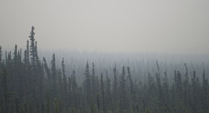 Figure 6. Smoke and spruce. A common early summer interior view – spruce emerging from a haze of smoke.
That’s the tradeoff, I guess. Moving fast between sensors, I can watch for things that help me sharpen the questions, but there is no time to ponder the processes, to vacate my mind of the need to hurry and thus achieve focus amid this vast silence. Analyzing the data on a computer screen later is a faster way to a publication, but not necessarily the path I originally sought. What might I know if I had made those 10,000 hourly observations, closer to a million across all sensors, or even all those in similar distributed sites between here and southern Alaska? Boredom, surely, but it’s a question worth asking – how many ways are there to be 30 C° or -40 C°? In the last three years, at this site anyway, the answer to the latter is none, but the former is not clear without other data.
Tomorrow, I will lug batteries around for sap flux sensors that can say how many ways there are to be 30 C° if you happen to be a P. mariana big enough to wear a sensor. I worry there are not more than three that big, that straight, in the whole valley.
 Figure 7. Boreal summer “sunset”. The sun stays high, but we are privileged to get a real sunset thanks to a nearby
fire.
What we can do in science with such tools is incredible. But what do we miss when we rely only on sensors, big data, and analysis with digital tools (some elegant and nearly surgical, but some closer to an excavator)? Not all that is numerically possible is worthwhile, and certainly not always scientifically defensible.
That’s what the field is for – checking our tendency to fool ourselves into thinking we know things we don’t actually know, or, worse, discounting things we suspect or know dimly but choose to ignore (Figs. 6, 7). And although my own relationship with wilderness has complicated considerably by adding fieldwork to it, I take no small joy in simultaneously walking through a lot of it and measuring its processes. With 24 hours of sun-above-the-horizon daylight available to me today, it could be quite a trip.
-All photos by the author